Aigues-Mortes
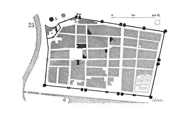
Core idea
Royal new town and crusader port — a perfect rectangular grid enclosed by complete ramparts, founded to give the French crown a Mediterranean harbor
Why it matters
The archetypal royal bastide: a planned, gridded, walled town created in a single act of statecraft; one of the best-preserved medieval planned towns in Europe
Description
Founded by Louis IX in the 1240s as a royal port giving the French crown direct access to the Mediterranean for the Crusades, Aigues-Mortes was laid out as a perfect rectangular grid of streets enclosed by a complete circuit of ramparts and towers, raised in a single act of state on marshy coastal flats.
Significance
Aigues-Mortes is the archetypal royal bastide — a planned, gridded, walled town willed into being by a monarch for strategic and commercial ends. One of the best-preserved medieval new towns in Europe, it shows planning as a direct instrument of statecraft.
What became of it
Founded by Louis IX from the 1240s as a royal new town and the kingdom's Mediterranean crusader port, with its rectilinear grid and complete ramparts finished around 1300; the harbour silted up and lost its role after Provence joined France in 1481, leaving the town to decline into a small, exceptionally well-preserved walled settlement.
Critique
The site was strategically and commercially fragile - built on marshland with no natural deep harbour, it depended on artificial channels and silted up, so the ambitious royal port became economically obsolete within two centuries.
What shaped it
- The Crusades (1096–1291)
- The grid (c. 2500 BCE)
- De Architectura (c. 15 BCE)
- Roman Twelve Tables — road law (c. 450 BCE)
Plans it influenced
- Monpazier (1284)
- Caernarfon (1283)
Sources
- https://en.m.wikipedia.org/wiki/Aigues-Mortes
- https://www.aigues-mortes-monument.fr/en/discover/history-of-the-towers-and-ramparts-of-aigues-m