Hanseong / Seoul (Joseon Capital)
Core idea
Confucian planned capital arranging palace, royal-ancestral shrine, state altar and markets within a mountain-ringed wall
Why it matters
The founding capital of the Joseon dynasty and a model application of classical Confucian capital doctrine
Description
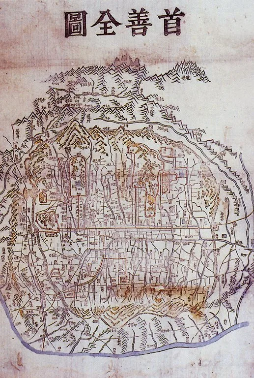
In 1394 King Taejo, founder of the Joseon dynasty, moved the capital from Gaegyeong to Hanseong, the site of modern Seoul, and began laying out a new city beneath Mount Bugak. Planned according to geomantic and Confucian principles, with the statesman Jeong Dojeon prominent in shaping its ideological order, the city set the main Gyeongbok palace against the northern mountain and arranged the Jongmyo royal-ancestral shrine, the Sajik state altars, government offices, avenues and markets in accordance with classical capital doctrine. A circular stone-and-earth fortress wall, some six metres high, was carried along the surrounding ridgelines, linking guarded gates and giving the capital both ritual structure and mountain-defined defence.
Significance
Hanseong is the definitive realisation of Confucian capital planning in Korea, encoding the hierarchy of palace, ancestral shrine, state altar and market into the city's physical form while binding it to a sacred mountain landscape. As the seat of the Joseon dynasty for over five centuries and the historic core of present-day Seoul, it durably fixed the structure, axes and walled perimeter that continue to organise the Korean capital.
What became of it
Realised substantially as planned around the palace-shrine-altar Confucian schema; functioned as the capital wall for 514 years (1396–1910). Much of the wall was demolished under Japanese rule and modernisation, though ~14.5 km survives or is restored and the city remains Seoul's core.
Critique
Recent scholarship argues the layout deviated from strict Kaogongji orthodoxy, adapting Confucian ideal-city principles to geomantic mountain-ringed topography rather than imposing a pure cardinal grid.
What shaped it
- Confucianism & Daoism (c. 5th c. BCE)
- Kaogongji (Artificers' Record) (c. 5th c. BCE)
- Fengshui landscape cosmology (Han onward, codified by Song)
- The baojia mutual-responsibility registration (Northern Song, c. 1070)
Plans it influenced
- Ming Beijing / Forbidden City (1406–1420)