Ming Nanjing (1368 Capital)
Core idea
First Ming capital with four nested circuits and a terrain-following city wall of over thirty kilometres
Why it matters
A monumental imperial capital that wrapped its walls around topography rather than imposing a pure cosmological grid
Description
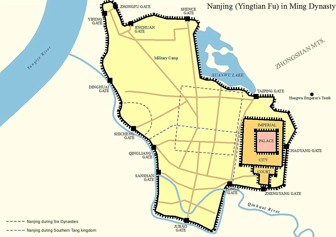
When Zhu Yuanzhang founded the Ming dynasty in 1368, he made Nanjing his capital and surrounded it with one of the most ambitious fortification systems ever built in China. Construction of the wall, begun in 1366 and continued for over two decades, produced an irregular circuit of more than thirty kilometres organised into a four-fold 'onion' structure of palace, imperial, inner and outer enclosures. Rather than describing a regular square, the wall wound to follow rivers, lakes and hills, incorporating natural defensive features and drawing high ground such as Lion Hill inside the defences. Some 350 million stamped, individually traceable bricks and elaborate barbican gates such as Zhonghua Gate made it a feat of military and administrative engineering.
Significance
Ming Nanjing combined the nested-enclosure symbolism of the Chinese imperial capital with a pragmatic, terrain-led wall that broke from the idealised orthogonal model. Its inner circuit survives as the longest extant city wall in the world, and the city's four-zone structure and topographic fortifications shaped imperial capital-building, informing the subsequent layout of Beijing and standing as a defining example of late-medieval Chinese urban order.
What became of it
Served as the first Ming capital 1368–1421 until the Yongle Emperor moved the capital to Beijing; the monumental walls largely survive and Nanjing remained a major city, so the plan was substantially realised and endures.
Critique
Population figures approaching one million are debated, as they conflate the densely settled walled core with a much larger, only partly urbanised suburban territory.
What shaped it
- Kaogongji (Artificers' Record) (c. 5th c. BCE)
- Fengshui landscape cosmology (Han onward, codified by Song)
- The walled-ward (fang) city system (Sui–Tang, c. 6th–9th c.)
Plans it influenced
- Ming Beijing / Forbidden City (1406–1420)