Place Stanislas ensemble, Nancy
Core idea
Three linked monumental squares stitching the medieval and new towns into one axial sequence.
Why it matters
The most accomplished French Baroque urban ensemble and an early architecturally unified public square.
Description
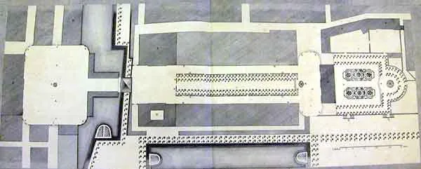
Built between 1752 and 1755 for Stanisław Leszczyński, the deposed king of Poland and then Duke of Lorraine, the ensemble was designed by the architect Emmanuel Héré de Corny. It links three spaces along a single axis: the rectilinear Place Stanislas, framed by buildings of uniform colossal order and closed by gilded wrought-iron screens by Jean Lamour; the elongated Place de la Carrière; and the Place d'Alliance. The axis, punctuated by the triumphal Arc Héré, deliberately connected the medieval old town with the seventeenth-century new town, while the place royale honoured Stanisław's son-in-law, Louis XV. The composition unifies architecture, ironwork and fountains into a single ordered scheme.
Significance
Place Stanislas is a canonical demonstration of the French place royale extended into a connected urban sequence rather than an isolated square. Its consistent architecture, decorative ironwork and axial planning made it an early model of the architecturally unified public space, influencing later civic design. By tying together two previously separate town fabrics it resolved a real urban problem, and the ensemble was inscribed as a UNESCO World Heritage Site in 1983.
What became of it
Realised (1752-1756) and superbly preserved; the three linked squares remain Nancy's civic heart and have been a UNESCO World Heritage Site since 1983.
What shaped it
- The Enlightenment (18th c.)
- The plaza / forum / agora (c. 500 BCE)
- Discourse on the Method (1637)
Plans it influenced
- Vienna Ringstraße (1857–)