Raffles Town Plan of Singapore (Jackson Plan)
Core idea
Colonial grid with segregated ethnic quarters founding the plan of Singapore.
Why it matters
Locked in Singapore's enduring ethnic-district structure and civic core.
Description
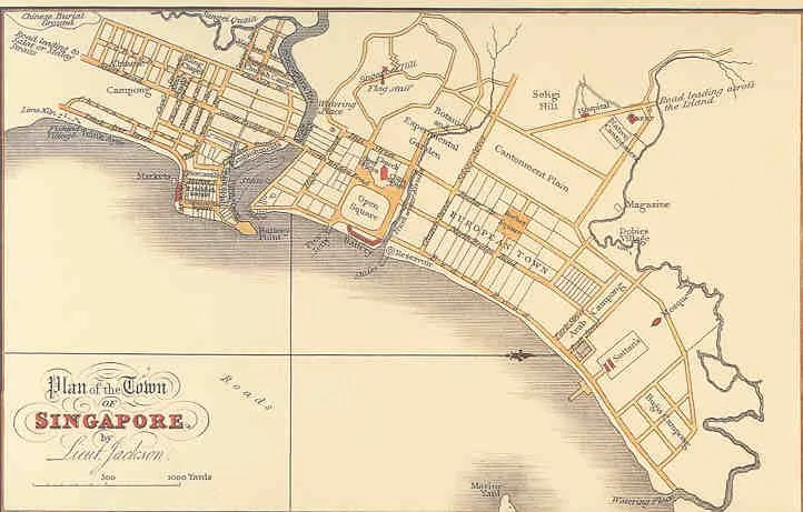
Drawn up over 1822–23 to instructions from Stamford Raffles and drafted by the engineer Lieutenant Philip Jackson, the Plan of the Town of Singapore set a right-angled grid adapted to the Singapore River, shoreline and hills. It allotted distinct quarters to different communities: a European town near the government reservation and Padang, a Chinese kampong south of the river, an Indian or Chuliah area upriver, and Kampong Glam for the Sultan, Bugis and Arab populations. Commerce was concentrated south of the river around Telok Ayer, and the plan codified the covered five-foot way and masonry, tiled-roof building standards.
Significance
Though never executed in full, the Jackson Plan became the founding template of colonial Singapore, fixing the city's lasting ethnic-district structure, today's Chinatown, Little India and Kampong Glam, and its civic core around the Padang. The five-foot way it regulated spread across Southeast Asia as a standard feature of the shophouse. As an early, explicit instrument of colonial spatial segregation, it remains a key document in the regional history of urban planning.
What became of it
The plan organised central Singapore into segregated ethnic and functional quarters (European Town, Chinatown, Kampong Glam, commercial district) along the Singapore River; its imprint persists in present-day district boundaries and street patterns.
Critique
Scholars criticise the plan for institutionalising colonial racial segregation, hard-wiring ethnic division into the city's spatial structure.
What shaped it
- The British Empire and modern colonialism (1600 – 20th c.)
- The grid (c. 2500 BCE)
- The Atlantic slave trade (16th–19th c.)
- Ocean-going caravel, galleon and navigation (15th–16th c.)
Plans it influenced
Sources
- https://en.wikipedia.org/wiki/Jackson_Plan
- https://www.roots.gov.sg/stories-landing/stories/the-singapore-story-through-60-objects/colonial