Schéma directeur d'aménagement et d'urbanisme de la région de Paris (SDAURP)
Core idea
Regional master scheme for greater Paris launching five new towns and the RER express-rail network
Why it matters
The canonical large-metropolitan regional plan and direct ancestor of today's SDRIF
Description
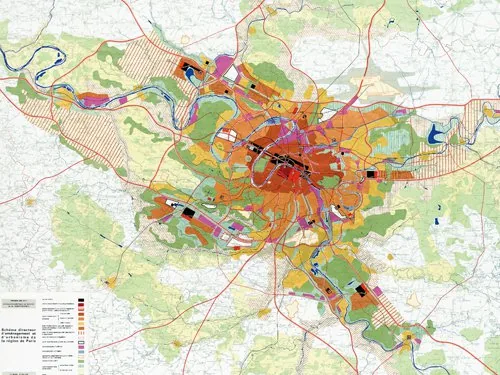
Adopted in 1965 under Paul Delouvrier, délégué général of the District of the Paris region, and prepared by the IAURP planning institute, the SDAURP was a strategic master scheme for the rapidly growing Paris agglomeration. Judging the earlier PADOG plan inadequate and projecting up to fourteen million inhabitants by 2000, it organised regional growth along preferential axes rather than concentric sprawl. Its principal instruments were five new towns — Cergy-Pontoise, Évry, Marne-la-Vallée, Sénart and Saint-Quentin-en-Yvelines — conceived as semi-autonomous development poles, served by a new regional express rail network (the RER) and supporting motorways to structure the metropolitan region.
Significance
The SDAURP is the canonical example of large-metropolitan regional planning, treating the Paris region as a single structured entity rather than a city and its suburbs. Its new towns and the RER reshaped the Île-de-France for decades, and it established the regional master-scheme tradition continued by later SDAU revisions and today's Schéma directeur de la région Île-de-France (SDRIF).
What became of it
Largely realised under Paul Delouvrier: five new towns and the RER express-rail network were built and remain central to the Paris region.
Critique
Population growth fell well short of forecasts, so the new towns were ultimately smaller than originally planned.
What shaped it
- The master plan (early 20th c.)
- Ville Contemporaine / Plan Voisin / Ville Radieuse (1922–1933)
- The metro / underground railway (1863)
- Survey-before-plan (1915)
- New Towns Act (1946)
- The Image of the City (1960)
Plans it influenced
- Lille Euralille 1 & 2 (1990s–2000s)
- Paris Rive Gauche (PRG) – 13e Arrondissement (1991)
- Cergy-Pontoise (ville nouvelle) (1969)
- Marne-la-Vallée (ville nouvelle) (1965)
Sources
- https://www.institutparisregion.fr/documents-historiques-de-reference/schema-directeur-damenagem
- https://fr.wikipedia.org/wiki/Sch%C3%A9ma_directeur_de_la_r%C3%A9gion_%C3%8Ele-de-France