Seoul Greenbelt (Development Restriction Zone)
Core idea
A restricted-development belt encircling Seoul to curb sprawl, on the British greenbelt model.
Why it matters
A landmark Asian metropolitan containment policy that shaped the region's growth for decades.
Description
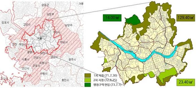
Introduced under the City Planning Law of 1971, South Korea's Development Restriction Zone, popularly the greenbelt, was first applied around Seoul in July 1971 at President Park Chung-hee's initiative. Modelled partly on the British greenbelt, the policy designated a ring of land in which development was tightly restricted to prevent contiguous metropolitan sprawl, protect surrounding open land and, given the proximity of North Korea, serve defence purposes. Strictly enforced through the authoritarian period, the belt's boundaries scarcely changed from the 1970s to the 1990s and was progressively extended to other Korean cities through the 1970s and 1980s.
Significance
Seoul's greenbelt is one of Asia's most prominent and durable applications of metropolitan growth containment, shaping the capital region's spatial structure for half a century. It demonstrated how an authoritarian developmental state could enforce strict land-use restriction at regional scale. Its later partial deregulation became a central debate in Korean planning and housing policy.
What became of it
Realised and largely durable, the greenbelt effectively curbed sprawl around Seoul, though portions have since been released for development.
Critique
The rigid belt inflated land prices and pushed development beyond it, displacing rather than preventing peripheral growth.
What shaped it
- The green belt (1898 concept / 1938 law)
- Barlow Report & green-belt policy (1940)
- The master plan (early 20th c.)
- Garden Cities of To-Morrow (1898 / 1902)
- Zoning (1884 Germany / 1916 NYC)
- The Japanese City Planning Law (1919 (revised 1968))
Plans it influenced
- Seoul New Towns (Bundang, Ilsan, etc.) (1990s)
- Seoul Cheonggyecheon Restoration Plan (2003–2005)