Warangal (Kakatiya Circular Capital)
Core idea
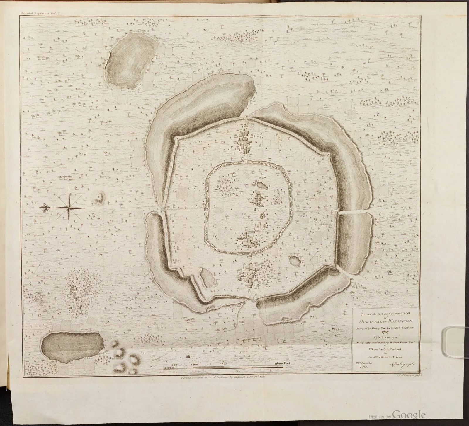
Radial-concentric Hindu fort-capital of three circular ramparts centred on a Shiva temple.
Why it matters
A rare realised mandala city, demonstrating cosmological circular planning at urban scale.
Description
Warangal was developed as the capital of the Kakatiya dynasty in the Deccan, principally under Ganapati Deva (reigned c. 1199–1262) and his daughter Rudrama Devi, with later strengthening by Prataparudra II. Its defining feature is a radial-concentric layout of three roughly circular enceintes: an inner granite wall about 1.2 km in diameter pierced by four cardinal gateways, a second earthen rampart attributed to Rudrama Devi some 2.4 km across, and an outer mud wall reaching roughly 12.5 km in diameter, all reinforced by moats. The scheme is centred on the Swayambhu Shiva temple, from which survive four elaborately carved kirti-toranas, the dynastic emblem, marking the cardinal axes of the cosmological plan.
Significance
Warangal is among the clearest surviving examples of a concentric, cardinally oriented mandala plan applied to a working capital rather than to a temple alone. Its nested circular ramparts and four toranas translate Hindu cosmological geometry into defensive urban form, prefiguring later South-Indian temple-towns. The fort remains a key reference for the study of medieval Deccan city-building and Kakatiya engineering.
What became of it
Realised as the Kakatiya capital (Orugallu) with radial-concentric rings centred on the Swayambhu Shiva temple; after the Delhi Sultanate's 1323 conquest the city was plundered, the central temple complex demolished, and it was renamed Sultanpur. The stone fort, gateways (Kala Thoranam) and bastions survive as ruins.
Critique
The grand concentric scheme was only partially completed and proved unable to withstand prolonged Sultanate siege, with the central temple complex demolished after capture.
What shaped it
- The vastu-purusha mandala diagram (c. 6th c. CE (codified))
- Vastu Shastra / Mayamata / Manasara (c. 6th c. CE)
- Temple-tank and eri (tank) irrigation hydraulics (c. 9th c. CE onward)
- The chakravartin universal-king ideal (c. 4th c. BCE onward)
Plans it influenced
- Vijayanagara (Hampi) (c. 14th–16th c.)