Second Regional Plan for New York
Core idea
Transit expansion, CBD decentralization
Why it matters
Reframed region for suburban era
Description
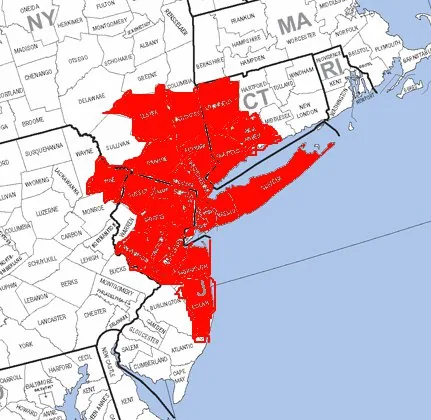
The Second Regional Plan, issued by the Regional Plan Association in 1968, reassessed the New York metropolitan region four decades after the association's first plan. Confronting mass suburbanisation, it argued for recentralisation around a strengthened Manhattan and a network of regional subcentres in older cities, backed by major investment in commuter rail and transit rather than continued highway-led dispersal.
Significance
The plan reframed American metropolitan planning for the suburban era, shifting the agenda from accommodating decentralisation to structuring it around transit and existing downtowns. Its advocacy of regional subcentres and rail investment anticipated later transit-oriented and smart-growth thinking, and it sustained the RPA's role as the leading voice of civic regionalism in the United States.
What became of it
Substantially influential, its mass-transit emphasis helped shape the MTA, the subway's recovery, NJ Transit and federal transit funding.
Critique
Several proposed regional sub-centres outside Manhattan never achieved the counterweight role the plan envisaged.
What shaped it
- The master plan (early 20th c.)
- The metro / underground railway (1863)
- The Death and Life of Great American Cities (1961)
- The urban freeway (mid-20th c.)
- The Image of the City (1960)
- Federal-Aid Highway Act (1956)
Plans it influenced
- Portland UGB + Metro 2040 (1979/1995)
- Arlington County Rosslyn–Ballston Corridor Plan (1980s–)
- Battery Park City Master Plan (NYC) (1979)
- Third Regional Plan for New York (1996)
- Fourth Regional Plan for New York (2017)
Sources
- https://rpa.org/work/reports/the-second-regional-plan
- https://en.wikipedia.org/wiki/Regional_Plan_Association