Zurich Richtplan + S-Bahn
Core idea
Rail/settlement integration
Why it matters
Strong rail-led metropolitan coordination
Description
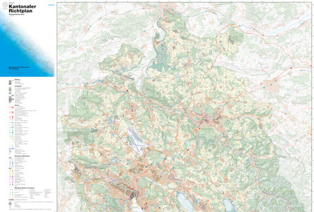
From around 1990 Zurich combined the cantonal Richtplan, the Swiss structure-plan instrument coordinating settlement and infrastructure, with the new S-Bahn regional rail network opened in 1990 to bind metropolitan growth to public transport. The framework directs development towards well-served nodes and corridors, protects landscape between them, and is backed by continuing investment in rail capacity and by city policies restraining car traffic and capping parking.
Significance
Zurich is widely regarded as a benchmark for rail-led metropolitan coordination, showing how a legally grounded structure plan, a high-frequency regional railway and restrictive traffic policy can together produce transit-oriented growth without a single master project. Its experience underpins the Swiss model of Abstimmung von Siedlung und Verkehr, the alignment of settlement and transport, which has influenced regional planning debates well beyond Switzerland.
What shaped it
- The metro / underground railway (1863)
- Garden Cities of To-Morrow (1898 / 1902)
- The master plan (early 20th c.)
Plans it influenced
- Geneva Projet d’Agglomération (2007–)
- Zurich 2000-Watt Society Implementation (2008–)
- Zurich Europaallee (2006–)
- Bern Agglomeration Programme (Agglomerationsprogramm Verkehr und Siedlung) (2007)
Sources
- https://en.wikipedia.org/wiki/Z%C3%BCrich_S-Bahn
- https://www.zvv.ch/en/about-us/zurich-transport-network/history.html