Groningen Traffic Circulation Plan
Core idea
Modal filtering; quadrant system
Why it matters
Pioneer of low-traffic city cores
Description
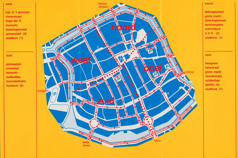
Groningen's Traffic Circulation Plan of 1977 divided the compact medieval city centre into four quadrants between which private cars could not pass directly, forcing motor traffic onto a ring road while cyclists and buses retained full cross-centre movement. Introduced by a young left-wing city council and implemented almost overnight, the scheme was a piece of regulatory rather than physical planning, achieving a radical reordering of the street network with paint, signage and enforcement rather than major construction.
Significance
The plan is a pioneering example of modal filtering at the scale of an entire city core, and it helped make Groningen one of the most cycled cities in the world. It has become a canonical reference for the low-traffic neighbourhood and circulation-plan movements of the twenty-first century, cited by cities from Ghent to Birmingham as proof that traffic can be restructured quickly and cheaply when political will exists.
What shaped it
- The Death and Life of Great American Cities (1961)
- The pedestrian zone (1953)
- Life Between Buildings (1971)
- The 1973 oil shock (1973–74)
Plans it influenced
- Ghent Circulation Plan (2017)
- Florence Tramway & PGTU (2006–)
- Leuven Mobility Plan 2030 (2021)
- Barcelona Superblocks (Superilles) (2016–)
- Paris Plan Vélo & RER Vélo (2015–2026)
- Munster Promenade & Cycling Network Plan (2000s–)
- Bolzano Mobility Plan & Ring (2013)
- London Mini-Holland (Waltham Forest etc.) (2014–)
Sources
- https://www.citysmiths.org/blog/2018/7/9/limiting-cars-privileging-bicycles-a-history-of-the-tra
- https://www.witpress.com/Secure/elibrary/papers/UT04/UT04029FU.pdf