Rotterdam Kop van Zuid Masterplan
Core idea
Bridging north–south with Erasmus Bridge and mixed uses
Why it matters
Catalyzed Rotterdam’s waterfront renaissance
Description
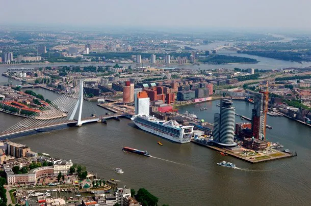
The Kop van Zuid masterplan of 1991, led for the City of Rotterdam by planner Riek Bakker with designs by Teun Koolhaas and others, redeveloped derelict port land on the south bank of the Maas opposite the city centre. Its central move was the Erasmus Bridge, opened in 1996, which tied the neglected south to the northern centre and anchored a new mixed district of offices, housing, cultural institutions and high-rise towers around the Wilhelminapier, where former warehouses and the Holland America Line headquarters were retained and reused.
Significance
Kop van Zuid catalysed Rotterdam's waterfront renaissance and its reinvention as a high-rise city, and it is the leading Dutch example of using a bridge and public investment as levers for regenerating port land. The project is studied for its deliberate strategy of social return for the adjacent poor districts of South Rotterdam, and it shaped subsequent Dutch waterfront schemes from Amsterdam's Eastern Docklands debates to later Maas-bank developments.
What became of it
Largely realised: the docklands area south of the Maas was redeveloped from the 1990s with the Erasmus Bridge, high-rise offices and mixed housing, becoming a flagship of Rotterdam's regeneration.
Critique
Critics note the scheme's high-end, image-driven character delivered prestige towers but only limited socio-economic uplift for adjacent deprived neighbourhoods.
What shaped it
- Postmodernism in architecture & planning (1977)
- The master plan (early 20th c.)
- Neoliberalism (1970s–1990s)
Plans it influenced
- Amsterdam IJburg (1997–)
- Rotterdam Stadshavens / M4H (2007–)
- Rotterdam Omgevingsvisie 2040 (2021)
- Rotterdam Feyenoord City / Stadionpark (2016–)
- Ghent Oude Dokken Masterplan (2010s–)
- Lyon Confluence Masterplan (2003)
- Rotterdam Hart van Zuid (2016–)
- Oslo Bjørvika / Barcode Redevelopment (2000s–)
Sources
- https://stadsarchief.rotterdam.nl/kop-van-zuid
- https://urbed.coop/sites/default/files/Case%20Study%20for%20Kop%20Van%20Zuid,%20Rotterdam.pdf