Angkor (Khmer Empire)
Core idea
Temple-mountain cities (Angkor Wat, Angkor Thom) on a vast hydraulic landscape — barays, canals, and moats structuring an urban region
Why it matters
Largest pre-industrial urban complex on Earth (~1,000 km²); Hindu-Buddhist cosmological planning at territorial scale
Description
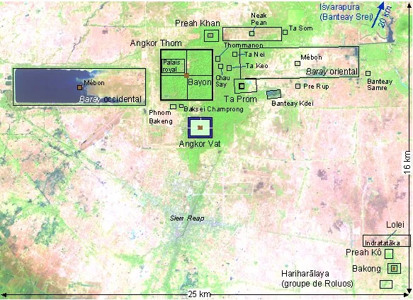
From the 9th to the 13th centuries the Khmer built, near modern Siem Reap, the most extensive pre-industrial urban complex on Earth — perhaps 1,000 km² of temples, palaces, and dispersed habitation woven into a colossal hydraulic landscape of reservoirs (barays), canals, and moats. Temple-mountains like Angkor Wat and the walled city of Angkor Thom modeled the Hindu-Buddhist cosmos in stone and water.
Significance
Angkor redefines what a city can be: a low-density, water-engineered urban region rather than a dense walled core. It demonstrates cosmological planning at territorial scale and offers a sobering case study in how climate and water-system stress can unravel even a vast and sophisticated civilization.
What became of it
The hydraulic city decayed after the 15th century as the empire shifted south; temples survived as ruins partly reclaimed by forest, now a conserved UNESCO archaeological park.
Critique
Groslier's 'hydraulic city' thesis has been critiqued and revised: the vast water network is now read less as centralised irrigation and more as a fragile system whose breakdown (with climate shocks) contributed to Angkor's decline.
What shaped it
- Vastu Shastra / Mayamata / Manasara (c. 6th c. CE)
- The vastu-purusha mandala diagram (c. 6th c. CE (codified))
- Hinduism & the Vedas (c. 1500 BCE onward)
- Buddhism (c. 5th c. BCE)
Plans it influenced
- Bagan (Pagan Kingdom) (c. 9th–13th c.)
- Historic Town of Sukhothai (c. 1238–1438 CE)
- Ayutthaya (Siamese Island Capital) (1351)
- Luang Prabang Royal City (c. 1353)